Severe Weather outlook
Storm Prediction Center
SPC Convective Outlooks
  • SPC 1300Z Day 1 Outlook
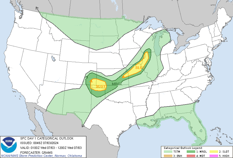
    Day 1 Outlook Image
    Day 1 Convective Outlook  
    NWS Storm Prediction Center Norman OK
    0750 AM CDT Sun Sep 15 2024
    
    Valid 151300Z - 161200Z
    
    ...THERE IS A MARGINAL RISK OF SEVERE THUNDERSTORMS ACROSS PARTS OF
    THE CENTRAL AND NORTHERN HIGH PLAINS...
    
    ...SUMMARY...
    Thunderstorms capable of isolated severe gusts and hail will be
    possible today across parts of the central and northern High Plains.
    
    ...Synopsis...
    In mid/upper levels, a blocky longwave pattern will remain over the
    CONUS, with amplifying troughing in the West and a Rex configuration
    in the East.  Cyclonic flow already covers most of the land west of
    the Rockies.  That will continue but with backing of the flow aloft,
    as a cyclone now centered over Vancouver Island strengthens and digs
    south-southeastward down the West Coast.  By 12Z tomorrow, the
    associated 500-mb low should be located near OAK, with strongly
    difluent flow and modest ridging over the High Plains from eastern
    NM to MT.  The southern part of a weak shortwave trough -- evident
    in moisture-channel imagery from UT to eastern AZ -- should cross CO
    today and reach the eastern border of WY to near GLD by 12Z, likely
    enhanced from this evening onward by convectively generated
    vorticity.
    
    A mid/upper anticyclone now over the Lower Great Lakes will stretch
    eastward and open up to that direction around the end of the period.
    The base of the eastern pattern block will be composed of a broad,
    nearly zonal height weakness anchored by:
    1. The decaying remains of Francine, long merged with a mid/upper
    low, and forecast to drift erratically over the Mid-South while
    weakening further;
    2.  An intensifying, deep-layer cyclone with low-level manifestation
    as a deepening wave cyclone along a frontal zone, offshore from the
    Carolinas.
    
    The 11Z surface analysis showed a wavy, quasistationary frontal zone
    attached to a strengthening low located roughly south of EWN and
    east of SAV.  The front extended across northern FL to the western
    FL Panhandle and southwestern AL.  A remnant low was drawn well
    inland over northern MS, connecting to the Gulf boundary via an
    occluded front.  These features should move little through the
    period, but with further weakening of the western low, and
    intensification of the eastern one.  Elsewhere, a lee trough and
    dryline either overlapped, or were drawn within less than 100 nm
    apart, near the eastern border of WY, eastern CO, the northern/
    western TX Panhandle, and east-central/southeastern NM.  The dryline
    should shift somewhat eastward today amid diurnal heating.
    
    ...Central/northern High Plains...
    Isolated to widely scattered thunderstorms are possible across a
    large part of the Rockies, Intermountain West, and Desert Southwest
    today.  Some of this activity will mature atop deep, well-mixed
    boundary layers of desert valleys and the High Plains, with non-zero
    potential for a strong-severe gust.  The most concentrated/organized
    potential for gusts near to above severe limits, as well as marginal
    hail, still appears to be over portions of the central High Plains
    into the Black Hills and vicinity, near the lee trough/dryline. 
    East of that, low-level moisture will be relatively maximized in a
    return-flow airmass of predominantly continental origin, with a
    north-south belt of 50s to mid 60s F surface dewpoints.  Where the
    western part of that moisture coincides with strong surface heating,
    and underlies the eastern part of the EML, a north-south corridor of
    MLCAPE in the 1500-2500 J/kg range should develop, with 500-1500
    J/kg extending into the more deeply mixed regime nearest the lee
    trough.  East of the trough, considerable veering of winds with
    height is expected, with some low-level hodograph enhancement
    potentially moving 0-3-km SRH to near 150 J/kg, but lack of stronger
    midlevel flow will temper overall shear.
    
    ...Coastal NC, extreme eastern SC...
    Many progs deepen the low-level cyclone and transition it to
    subtropical or tropical character through the end of day 2, while
    eroding the frontal zone's baroclinicity; however, inconsistency
    among models is high.  The most aggressive among the synoptic and
    CAM guidance with the speed of the transition and approach to the
    coast (e.g., 06Z GFS and 00Z ARW high-res window respectively) show
    favorably large low-level shear, but barely have surface-based
    effective inflow onshore at the end of the period, with greatest
    convective coverage and buoyancy still offshore.  As such, the
    associated coastal tornado threat still appears too low and
    conditional to outlook until day 2 (after 16/12Z).  Potential for
    faster/deeper development and shoreward translation of the low will
    continue to be monitored for onshore supercell threat the last few
    hours of day 1.  See latest NHC tropical outlook for guidance on
    overall development potential with this system.
    
    ..Edwards/Mosier.. 09/15/2024
    
    
    Read more
  • SPC 1630Z Day 1 Outlook
    Day 1 Outlook Image
    Day 1 Convective Outlook  
    NWS Storm Prediction Center Norman OK
    1128 AM CDT Sun Sep 15 2024
    
    Valid 151630Z - 161200Z
    
    ...THERE IS A MARGINAL RISK OF SEVERE THUNDERSTORMS ACROSS PARTS OF
    THE NORTHERN/CENTRAL PLAINS...
    
    ...SUMMARY...
    Thunderstorms capable of producing isolated severe gusts and hail
    may occur today and tonight across parts of the northern/central
    Plains.
    
    ...Northern/Central Plains...
    An amplified upper trough along/near the West Coast this morning
    will further evolve into a closed upper low over northern CA and
    vicinity by late tonight. Ahead of this feature, modestly enhanced
    south-southwesterly mid-level flow will be in place over much of the
    western states and Rockies through the period. Although low-level
    moisture is expected to remain limited over much of this region,
    isolated strong to severe gusts may occur with any thunderstorms
    that can develop in a deeply mixed boundary layer favorable for
    gusty downdraft winds. 
    
    Latest guidance continues to suggest that a relatively greater
    concentration of severe potential will be focused across parts of
    the northern/central Plains late this afternoon through tonight.
    Across this area, a weak surface lee trough and greater low-level
    moisture to its east should support weak to moderate instability
    with daytime heating. Steep mid-level lapse rates should also aid
    updraft accelerations/intensities, with around 20-30 kt of
    deep-layer shear supporting modest thunderstorm organization.
    Isolated severe hail may occur with initially more discrete
    convection, but a tendency for clustering should lead to a
    relatively greater wind threat with time as convection spreads
    generally east-northeastward through the evening. Regardless, the
    overall severe threat from northeast CO into western NE/SD and
    vicinity should remain fairly isolated/marginal given the modest
    deep-layer shear.
    
    Low-level warm advection is forecast to increase across much of the
    northern/central Plains tonight as a southerly low-level jet
    strengthens. A surface warm front is also expected to lift northward
    over ND late tonight into early Monday morning. With steepening
    mid-level lapse rates overspreading the northern Plains in tandem
    with increasing low-level moisture, ample MUCAPE should be
    available. Most guidance shows at least isolated convection
    developing across parts of ND tonight in this favorable
    thermodynamic environment. Although deep-layer shear may remain
    fairly modest, it may still be sufficient for updraft organization
    and an isolated threat for severe hail with any elevated convection
    that can form. Have therefore expanded the Marginal Risk northward
    to account for this potential.
    
    ...Coastal Carolinas...
    Latest NHC forecast continues to indicate some potential for
    sub-tropical or tropical development of a surface low currently off
    the SC Coast. Regardless of development, it still appears that the
    more moist/tropical low-level airmass over the Gulf Stream will
    struggle to advance inland over coastal portions of NC/SC through
    the end of the Day 1 forecast period early Monday morning (16/12Z).
    Accordingly, tornado potential with any low-topped supercells on the
    north to northeast periphery of the surface low should tend to
    remain offshore until Day 2/Monday (after 16/12Z).
    
    ..Gleason/Moore.. 09/15/2024
    
    
    Read more